
“One might almost have walked over the Thames and through every part of it on the boats, which could scarcely pass by each other.” This description of a regatta in 1775 can be followed by one from “Paddler,” a newspaper correspondent, who, on July 3, 1880, seeking relief “in the enjoyment of a leisurely paddle on the river in these long twilight evenings,” faces “the noisy and immodest proceedings of the evenings” and their “foul and disgusting language which assaults one’s ears and serves to call attention to the immodesty which might otherwise pass unnoticed.” Or take T. S. Eliot, working diligently for the Colonial & Foreign Department of Lloyds Bank and finding, in Thameside London, intimations of the prospect of salvation described in The Waste Land (1922):
“This music crept by me upon the waters”
And along the Strand, up Queen Victoria Street.
O City city, I can sometimes hear
Beside a public bar in Lower Thames Street,
The pleasant whining of a mandolin
And a clatter and a chatter from within
Where fishmen lounge at noon: where the walls
Of Magnus Martyr hold
Inexplicable splendour of Ionian white and gold.
At once barrier and route, the Thames has been crucial to London’s history, development, identity, and imagination. It helps explain much about London’s role in the history of England and that city’s leading place in Britain’s interaction with the wider world.
Cities have to contend with water’s role as an obstacle, which is why they tend to be located at convenient bridging points. The use of water as a means for trade, by sea and river, is the other crucial factor. Until the development of bridges and tunnels able to cross large expanses of water, and of aircraft (more particularly air freight), there was a reliance on ships as the means to move people and goods overseas. That was crucially important for England and made it different from France. Moreover, as far as England was concerned, the problems of overland routes—including a dependency on horses, which had limited load capacity, as well as variable and often poor road surfaces—especially for the bulk movement of goods, made transport by water preferable. Such transport faced many problems, notably so prior to the application of engineering knowledge in the eighteenth century and of steam power in the nineteenth. In large rivers, it was not always easy to sail against the current. Variable water levels increased the hazards of navigation and brought perilous shoals into play. Winter freezing, snowmelt spate, and summer drought were all issues for aquatic transport. The large-scale canalization of rivers, so crucial to the flourishing of trade, did not begin until the eighteenth century.
All these issues posed potential problems for river-goers. They also ensured that particular rivers had attractions. The Thames was one such—its flow being more equable and its course easier to manage than those of most other major European rivers.
There was also the crucial issue of the hinterland, in the sense of the area abroad served by particular ports. For Britain, the significant land abroad for centuries was Continental Europe. Ireland, in contrast, offered prospects but not the same prosperity. It was a source for raw materials, but not a significant market. The westward-facing ports, first Bristol, did not rise in relative significance until England became a major player in the Atlantic economy.
Prior to that, the focus was on ports along the coast from Southampton, on England’s south coast, to Leith, near Edinburgh. Ports such as Dover, London, Ipswich, King’s Lynn, Hull, Newcastle, and Berwick all had a role to play in Britain’s economy. There were opportunities and drawbacks for each of these ports. Leith, Berwick, Newcastle, and Hull all had useful hinterlands in Britain, but none on the scale of those ports further south, while the extent of the North Sea that had to be covered was greater, thus introducing more unpredictability for shipping. Anglo-Scottish hostilities also ensured that there were major protection costs in the case of the ports of Leith, Berwick, and Newcastle.
Had England’s destiny been decided by links with the Viking world—as had seemed likely to be the case with the kingdom of York in the tenth century, and with Danish rule and Norwegian invasion in the eleventh—then Hull would presumably have had a greater role, providing as it did a direct passage to York. The success of the Old English monarchy in the tenth century, its revival under Edward the Confessor (r. 1042–66), and the triumph of the Normans successively ended this option. Power came to be located further south.
This ensured that a range of ports would have to be employed, from King’s Lynn to Southampton. All were important, and had the Old English state continued to be based in Winchester, then Southampton would probably have been the key port in all of England. King’s Lynn and Ipswich were well suited to serve East Anglia, and a host of ports existed to service Kent and Sussex. Yet all of these options faced problems if we look at a wider market, both politically and economically. The Midlands, and notably the West Midlands that were the center of Mercia, were best linked to Continental Europe via the Thames Valley. From King’s Lynn and Ipswich, there was much land to cover to get to Mercia, and a good portion of this territory was often waterlogged. Dover and the Cinque Ports faced major issues of distance, which were exacerbated by the Wealden Greensand and the need to cross both the Rivers Medway and Thames.
In London it was possible to draw on links with East Anglia, Kent, and Mercia, as well as Wessex, thereby covering much of England. London’s potential, as at once a political and an economic center, had been perceived by the Romans, as had that of York. The concentration of wealth and power in the south of England, as well as its closeness to the Continent, ensured that, of the two, London won out. It was a city defined by crossing the Thames and developing links to the Continent. That first aspect has been represented most particularly by the famous bridge, but much traffic in and around the city was also by boat.
The significance of London Bridge was a testimony to the importance of the river. London was established at a strategic location on the north bank of the Thames, which was then much wider than it is today. Not only was the southern bank then characterized by marshy tidal inlets, but, on the northern shore, land has since been reclaimed over the centuries, and the riverbank has moved progressively out into the river, in part to allow the construction of successive lines of river defenses and new wharves. The waterfront the Romans found lay along the line of modern Upper and Lower Thames Streets. Today, the river is tidal as far west as Teddington, some seventeen miles from London Bridge. In Roman times, the river was tidal possibly not much further upstream than the low gravel banks on the northern side, which provided a good site for the Romans to build the first bridge—and which remains the site of today’s London Bridge. The two low hills of Ludgate and Cornhill were also attractive factors in the choice of site.
The early balance between military and civilian uses for bridge, harbor, and settlement would have favored the military, as lowland Britain was being conquered, but this balance rapidly changed. As the lowest bridging point on the Thames, London was a key place in the internal transport system and more suitable as a center of English life than the original official capital of Roman Britain, Colchester. The role of London as a leading port made it different from other major Roman centers, such as York, Lincoln, Chester, and Gloucester, although each of those was also a river port. Proximity to the English Channel ensured London a central role in British life.
The river’s utility for trade helped foster English resilience in the Anglo-Saxon period. The locations of Anglo-Saxon settlement at first reverted to those of the pre-Roman centuries. In time, because of the advantages of the river, trade revived, and a new port town, Lundenwic, developed to the west of Londinium.
The revival of commerce in England in part reflected the improvement of conditions in Merovingian Gaul, with which there was considerable trade via the port of Quentovic, near Boulogne. There was also trade to the Low Countries. Initially, the two major water systems in England centered on the Wash/Humber in the northeast and Severn/Avon in the southwest, but the latter declined from the late sixth century as the related trade from the Mediterranean via Atlantic Spain and France to Cornwall fell. Instead, the Thames system centered on London grew in significance, a system that also benefited from tributaries such as the Lea, which runs north from London. The advantages of Roman London—which had linked a key water route to land routes along the better-drained ridges—were rediscovered. The greater role played by bridges in the period is suggested by the extent to which, from the 740s, labor service for bridge-building and repair became an important provision in legal charters. The Roman bridge in London was possibly rebuilt in the mid-ninth century and later repaired under Aethelred the Unready.
Moreover, the spreading authority, first of the Kingdom of Mercia, and then of Wessex, diminished the role of the Thames as a boundary from the eighth century onwards, which greatly benefited London.
London’s dynamism interacted with that of England, both politically and economically. From the ninth century, English cloth exports were earning large amounts of Continental silver, which helped to make England particularly wealthy. The strength of the English monetary economy gave London a specific advantage as a commercial city and assisted the process of government. Money and politics have always gone hand in hand, and London’s status as England’s primary financial center cemented its role as the political capital. Control over London was important in the politico-military crises of 1016, 1052, and 1066 and a major factor in the city wars of Stephen’s, John’s, and Henry III’s reigns, and later in the Wars of the Roses.
Commercial dominance remained a theme in England, a dominance that owed much to the opportunities provided by the Thames. London as a site allowed for links between domestic and international trade and more general opportunities via roads, the sea, and the conveniences that the urban environment offered for transhipment. London’s profits derived from its intermediary role in multiple economies. The city benefited from its ability to play a major part in serving trades to the north of England and up to Scotland, to the Low Countries, and to the southern markets of France, Spain, and Italy. This primacy in transhipment also increased the gap between London’s position and that of the other east-coast ports.
Moreover, growth in the Thames trade was helped by developments in commercial infrastructure and organization. The movement of anchorages downriver to Deptford, Wapping, and Ratcliffe provided more space for shipping. London’s first dry dock was built at Rotherhithe in 1599, followed by another, for the expanding East India Company, at Blackwall in 1614–17. In 1661, the diarist Samuel Pepys took a barge to Blackwall and “viewed the dock and the new Wet dock, which is newly made there, and a brave new merchantman which is to be launched shortly.” Ships could be repaired and fitted out there, but the docks were not yet used for loading; that would have to wait for a later succession of dock schemes starting at the end of the seventeenth century. The value of London’s docks led Valentine Knight, in his proposal for rebuilding the City after the Great Fire, to suggest constructing a canal from the Thames via the heart of the City to the (now-subterranean) River Fleet in order to provide additional space for wharves.
Organizational sophistication, financial firepower, and the rule of law were all significant factors in the development of trading companies, such as the East India, Hudson’s Bay, and Levant Companies, which could raise investment and share risk from a wide range of participants. The Thames economy also benefited from the protectionist legislation of the Navigation Acts of 1650, 1651, and 1660, and from measures to prevent foreign shipbuilding. Indeed, in 1698, Peter the Great of Russia came to the Royal Dockyards at Deptford to see shipbuilding in progress, as he searched for foreign models for the industry he intended to establish. Shipbuilding reflected the powerful role of the Thames, not only in shaping London and its transport links, within and outside the city, but also in its economy.
Around the time of Peter’s visit, London and Britain’s first commercial wet dock was constructed. Built at Rotherhithe, initially as a safe anchorage and ship-repair facility, it came to be known as Greenland Dock because of its links with the whaling industry.
The Thames, with its increasing dockage space, became important to a direct-trading economy, rather than an intermediary one dependent on the Dutch. This trading, which required more capital resources and expenditure, and a more sophisticated organizational structure, enabled the London merchants to bear the bulk of the transaction costs themselves, and also to take much of the profit.
By 1682, 70 percent of the coal shipped from the Tyne went to London. Water routes also remained crucial within England. At the start of the eighteenth century, cloth was generally taken from Stroud, in Gloucestershire, to London by Thames barge from Lechdale, seventy miles west of the capital. With the advent of turnpikes, road links developed for individuals, but water remained crucial for freight. It cost £1.67 a ton to move goods by road from London to Reading in 1792, but only 50 pence a ton by water. That lower cost ensured the commercial dominance of water routes for years to come.
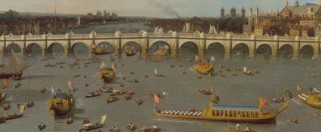
At the same time, the river’s role as a barrier was increasingly tackled, reflecting the importance of London and the availability of resources to undertake the task. Several river ferries were replaced by new bridges, in a development that reflected human control over the environment, as ferries were subject to river conditions such as ice and other adverse weather whereas bridges held no such drawbacks. The first new bridge was built at Dachet, near Windsor, in 1706; demolished in the 1840s, this is the only Thames bridge that no longer exists. Dachet was followed by Putney (1729), Westminster (1738–50), Walton (1750), Hampton Court (1753), Kew (1758–59), Blackfriars (1760–69), Battersea (1771–72), and Richmond (1774–77). Although it challenged the passenger traffic by ferry, the building of Westminster Bridge markedly helped development on the southern bank of the Thames. But the halfpenny toll demanded from those who crossed Blackfriars Bridge led to a riot.
Meanwhile, the status and confidence brought by thriving trade led to the depiction of Father Thames as a reborn Neptune, for example in James Barry’s paintings for the Society for the Encouragement of Arts, Commerce and Manufactures (now the Royal Society of Arts), executed between 1777 and 1783, and in John Bacon’s 1789 bronze statue of George III in the courtyard of the riverfront Somerset House. As in Rome, where Father Tiber is an ancient symbolic figure, the derivation of the phrase (Old) Father Thames comes from the centrality of the river to the city’s origin, fortunes, and growth. Malachy Postlethwayt, in his influential Universal Dictionary of Trade and Commerce (1766), referred to London as the “grand central mart,” while the press focused its reports on grain prices on those at Bear Quay, where grain was landed.
In the nineteenth century, the growth of trade was accompanied by a major expansion in shipping and docks. Indeed, there was a drive for new docks in the first years of the nineteenth century. The first to open, in 1802, was the pair of docks known as the West India Docks, which cleverly cut across the neck of the Isle of Dogs in order to provide entrances at both ends of the dock complex; the northern dock was used for ships unloading, while the southern, “Export,” was for loading. Meanwhile, the excavations for London Dock at Wapping had begun in 1801. Like the West India Docks, this twenty-acre dock was furnished with a comprehensive range of warehouses and was later extended to the east, in part to provide a second point of access from the river. Further downstream came the East India Docks, at the northeast end of the Isle of Dogs, in 1805. On the southern bank, work began on the Surrey Commercial Docks in 1807.
The dock-building reflected the acute congestion on the Thames and its wharves in the 1790s, as overseas and domestic trade expanded. In the year 1800, some 1,800 vessels were being moored in the river, rising to 16,000 in 1824. There were innumerable complaints of lengthy delays before a berth was available, which was exacerbated by the fact that whole flotillas of cargo ships would tend to arrive simultaneously when the winds and tides gave favorable sailing conditions. Vessels would moor in the river, their cargoes transferred to small, unpowered barges known as “lighters,” which would take the goods to the wharves. Before steam tugs began to be used to tow the lighters, they were maneuvered using only long oars known as “sweeps” and by taking advantage of the tides and winds, a highly skilled job that required considerable knowledge of the “set” of the tides. At low water in dry seasons, the Thames is not particularly deep, even today often less than seven feet in places. This depth could be reduced by silt deposition, and by ships dumping ballast, so dredging was important at a time when the river wharves were so busy.
Unlike at Liverpool, the building of the docks on the Thames was done by private companies rather than the municipal authority and was generally undertaken in an unplanned, rather chaotic fashion. A major factor in this was the “Free Water Clause,” initially a provision of the West India Dock that from 1799 on applied to the other dock schemes. This allowed lighters free access to the docks, where they could unload ships and move the goods out into the river to be landed at the river wharves, all free of toll or charge. This system cost the dock companies dearly but helped to preserve the bustling, congested, and chaotic trade of the many river wharves to an extent and in a manner not seen in any other British port.
The importance of the Thames within Britain’s commercial system was enhanced by canal construction, enabling greater quantities of goods to be transported to the City and port of London from elsewhere in England. By the late 1760s, London’s first true canal, the Limehouse Cut, had connected the ancient River Lea Navigation with the Thames. More important, from the 1790s, the Grand Junction Canal provided a link between the Thames at Brentford and the Midlands that eliminated the need for the long river journey up the Thames to Oxford to join the earlier Oxford Canal. A further connection was provided between the Grand Junction and the Thames at Limehouse Basin via the Regent’s Canal. Completed in 1820, the Regent’s also wound its way around parts of north London that were undergoing rapid development at this time, and therefore provided a transport link for them.
More docks followed the Napoleonic Wars. In a major development involving the demolition of 1,250 houses, the St Katharine Docks were shoehorned into the space between the Tower of London and the London Docks, becoming in 1828 the furthest upstream of the excavated docks.
As shipping increased in size and volume, new docks became ever larger and were built further downstream. The Royal Victoria Dock of 1855 was able to cater to the large steamships of the day and could handle massive quantities of goods; like Liverpool’s Albert Dock, it was a pioneer of hydraulic power for handling goods. Millwall Dock followed in 1868, the Royal Albert Dock in 1880, and Tilbury Docks, around twenty-five miles downstream in Essex, in 1886. The total investment was formidable. Royal nomenclature reflected the grandeur of the docks as well as official endorsement of their purpose. London’s waterfront housed at any one time more vessels than any other port on earth and was a counterpart of the city’s role in the financial architecture of the world.
Seaborne coal, mostly from Newcastle, was crucial to London’s flourishing. Only in 1869 was the coal brought to London by sea matched by that moved by rail, and, ten years later, some 3.5 million tons still entered the city by the Thames via ship. By now, however, the Thames had become less important than hitherto for shipbuilding, which was more in evidence on the Clyde, the Tyne, and the Wear, each near centers of ironworking. London’s shipbuilding was also hit by the greater costs of industry in London, including higher wages and overheads.
Those factors help to explain the failure in developing a broader base of heavy industry in London’s downriver. Meanwhile, a cosmopolitan maritime population crowded the riverside areas, embarking on, or disembarking from, vessels. This was very much an environment molded by man. In 1913, Arthur Sarsfield, a crime reporter who, under the pseudonym Sax Rohmer, published the successful novel The Mystery of Dr. Fu-Manchu—about a sinister Chinese master-criminal based in Limehouse—described a journey down the Thames, with the “oily glitter of the tide,” while “on the Surrey shore a blue light . . . flicked translucent tongues against the night’s curtain,” a gasworks. The pollution had already brought the fishing industry on the river to an end.
Maritime trade ensured specialization, and it helped to diversify the industrial base. Individual wharves specialized in particular trades: Hubbuck’s Wharf in paints, Morton’s Sufferance Wharf in preserved foods, chocolate, and confectionary, and Millwall Dock in grain. Canary Wharf, now the site of many financial-services firms, handled fruit from the Canary Isles.
The situation on the docks was very much less favorable by the late twentieth century. In part, this was due to factors general to the British economy, but it also owed to more specific issues. After being targeted and damaged in the Blitz, the docks were again thriving in the 1950s. But they declined rapidly thereafter with the redrawing of global trade routes as imperial flows ebbed. These challenges were exacerbated by the failure of the port to match competitors benefiting from post-war development.
In particular, militancy by trade unions encouraged the shift in freight business to Rotterdam. The first British container ship sent to Australia, the Encounter Bay, sailed from Rotterdam in 1969 because of an industrial dispute at Tilbury. Moreover, ports such as Felixstowe and Dover proved better able to respond to the challenges and opportunities of containerization because they were less unionized, whereas the London docks faced serious and persistent labor problems. Aside from containerization, there was a rise in roll-on, roll-off trade, with trucks driving directly onto ferries, which benefited Dover, Felixstowe, and Harwich.
With London’s maritime trade focused nearly thirty miles downriver at Tilbury, the derelict Docklands provided an unprecedented development opportunity near the center of a major city. The redevelopment of St Katharine Docks, closed to commercial traffic in 1968, was followed in 1981 by the establishment of the London Docklands Development Corporation. By 2003, Canary Wharf contained 13.1 million square feet of office space.
The river meanwhile lived on in a variety of ways, with the first salmon caught in the Thames in a century in 1974. Very differently, installed between that year and 1982, the Thames Barrier was designed to prevent excessively high water levels from reaching central London.
The Thames remains a central challenge to London’s future, even if this challenge is far less apparent to its citizens than it has been in the past. Modern cities, like London and New York, may turn their back on the water, but to do so is to neglect the living history and prospects for varied futures it represents.